
Road Trip to North Central Oklahoma - Part II
My road trip continues at the Oklahoma/Kansas state line, near Braman, OK, the first marker in Oklahoma on Hy 177 is about 3 miles north of Braman.
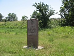
Braman, OK - Oklahoma War Chief
Still headed down HY 177 to Sumpter where I turn east on Peckham Road that was just a rough/gravel/blacktop road and head for Newkirk.

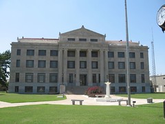
Newkirk, OK - Newkirk Historical District - Kay County Courthouse


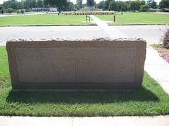
Kay County War Memorial - "Land of Hope"
Now back on the road I am going to Ponca City next on Hy 177.


Ponca City, OK - Pioneer Women Museum - Cherokee Outlet - 1866 Cherokee Outlet 1893


"Pioneer Woman" - Marland Estate - Marland Mansion
It's hot(104) and time for another pit stop, this time I had to get gas and ice tea. When I got back in the car decided to change shoes, I got in the back seat thinking my shoes were there, so I took of my shoes and sock then I found out my other shoes were in the front, so I got out onto the concrete in my bare feet, ouch! was that concrete hot, so I hurried up to get back in the car and I had my ice tea cup in hand and managed to spill it all over my shirt getting into the car. My next stop was suppose to be Stillwater but as I head down HY 177, I see a sign that read Marland, and I still have plenty of daylight left so I turn west onto Badlands Road so I follow it to intersection I turn north onto Hy 156 I go threw Marland and about a mile out of town I find the sign for the 101 Ranch on the west side of road, on the east side was the White Eagle monument and 101 Ranch Tower , I take pictures and start to look for the ranch and I drove a mile square and never found it. I so I back tracted on Badland Road to Hy 177 and turn south, Stillwater here I come.


Marland, OK - 101 Ranch - White Eagle Monument Hill - 101 Ranch Tower
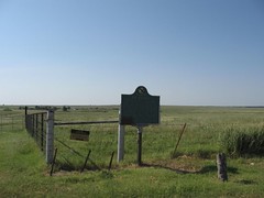
I saw a historical marker sign up a head and I turned to the west and followed the sign, I found the Otoe Missouria Cemetery and drove around and finally found the marker. I forgot to write down the location and GPS now I am going to have to do some research.


Red Rock, OK (area) - Otoe Missouria Cemetery Gate - Otoe Missouria Cemetery - First All Indian War Mothers Chapter - First All Indian War Mothers Memorial
Finally I made it to Stillwater I was suppose to look for 3 markers on Hy 40 but I couldn't find Hy 40 or the markers. I made my way downtown and took pictures of courthouse and train depot.Braman, OK - Oklahoma War Chief
Still headed down HY 177 to Sumpter where I turn east on Peckham Road that was just a rough/gravel/blacktop road and head for Newkirk.
Newkirk, OK - Newkirk Historical District - Kay County Courthouse
Kay County War Memorial - "Land of Hope"
Now back on the road I am going to Ponca City next on Hy 177.
Ponca City, OK - Pioneer Women Museum - Cherokee Outlet - 1866 Cherokee Outlet 1893
"Pioneer Woman" - Marland Estate - Marland Mansion
It's hot(104) and time for another pit stop, this time I had to get gas and ice tea. When I got back in the car decided to change shoes, I got in the back seat thinking my shoes were there, so I took of my shoes and sock then I found out my other shoes were in the front, so I got out onto the concrete in my bare feet, ouch! was that concrete hot, so I hurried up to get back in the car and I had my ice tea cup in hand and managed to spill it all over my shirt getting into the car. My next stop was suppose to be Stillwater but as I head down HY 177, I see a sign that read Marland, and I still have plenty of daylight left so I turn west onto Badlands Road so I follow it to intersection I turn north onto Hy 156 I go threw Marland and about a mile out of town I find the sign for the 101 Ranch on the west side of road, on the east side was the White Eagle monument and 101 Ranch Tower , I take pictures and start to look for the ranch and I drove a mile square and never found it. I so I back tracted on Badland Road to Hy 177 and turn south, Stillwater here I come.
Marland, OK - 101 Ranch - White Eagle Monument Hill - 101 Ranch Tower
I saw a historical marker sign up a head and I turned to the west and followed the sign, I found the Otoe Missouria Cemetery and drove around and finally found the marker. I forgot to write down the location and GPS now I am going to have to do some research.
Red Rock, OK (area) - Otoe Missouria Cemetery Gate - Otoe Missouria Cemetery - First All Indian War Mothers Chapter - First All Indian War Mothers Memorial


Stillwater, OK - Payne County Courthouse - Stillwater Veteran Memorial - Stillwater Trail Depot
After a quick pit stop and got another ice tea (yuck it was bad), lid loose spilt in on my shirt again (poor shirt). I turn on Hy 51 east headed for Ingalls, about 7 miles I find the Outlaw Battle marker then I turn south and go to Ingalls, when you get to the "T" in the road you go east, the "Battle of Ingalls" is about a block on the right. There is a monument, house, and sign telling about the outlaw battle.
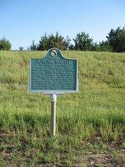

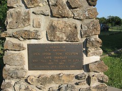


Ingalls, OK - Outlaw Battle - "Battle of Ingalls" Monument - "Battle of Ingalls" Memorial Plaque - "Battle of Ingalls " House - "Battle of Ingalls" sign.
It is getting late and the sun is getting lower in the sky, harder to take pictures, I leave Ingalls and go back out to Hy 51 go west to Hy 108 turn south and head for Ripley, next I turn on Hy 33 west I head for Guthrie, I then get on I-35 south and go to exit 143, get off and turn east on Covell Road, I travel about 3 miles to Douglas road, continue on east to the Gower Cemetery on the south side of road. Gower Cemetery is a very old cemetery for African American who settle the area in 1889, and is on the National Register of historic Place.


Edmond, OK - Gower Cemetery Gate -Gower Cemetery Historical Monument - Gower Cemetery Monument - Gower Cemetery.
The last picture of the day was taken and I headed back to I-35 to the Kilpatrick Turnpike, Oklahoma City, going west into the sunset and exit right at the Rockwell exit and go to Council road, and then south to the apartment complex. It was 8:45 pm and 377 miles traveled.
My road trip to North Central Oklahoma is at and end.