Looking For Fred (Part 1)
"Who is Fred," you ask?
Well Fred was an old town in Indian Territory, before Oklahoma became a state.
Fred, I.T. was located between Ninnekah and Chickasha, Oklahoma. It was on the Chisholm Trail, on the railroad, and had a Post Office in 1882.
My search began when I took the task to find Fred for the BlogOklahoma.us website. Fred was one of the historical sites I wanted to locate in Grady County. (Information has been posted on BlogOklahoma.us, telling of the history of Fred.)
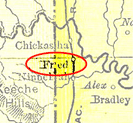
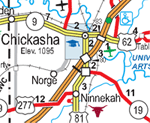
I spent many nights searching Google for information about Fred. I even found a map (1895 U.S. Atlas Oklahoma) that showed the location of Fred.
 1895 |
 2005 |
Finally the day arrived for my search to begin. My digital camera was charged, I had plenty of gas in the car, and it was only 103 degrees outside.
I headed out from Marlow, which is about a 30 mile trip to Ninnekah. I had planed to start my hunt from a road that was suppose to be marked "Old Fred Road", but just as I got to the turn to Ninnekah, I had to detour because of an auto accident on the bridge on Highway US 81.
Since I had directions to Muncrief Cemetery, an old cemetery dating back to 1862-1891 where some of the residents of Fred were buried, I went ahead and started looking for it because is was not out of my way, and Fred was supposed to be there close by on "Old Fred Road".
I followed the directions and signs to a road that was suppose to be "Old Fred Road" (it wasn't marked that because of the 911 telephone system all the roads had numbers instead of the name). At the end of that road was the sign to the Muncrief Cemetery. I decided I wouldn't go to the Cemetery, because I would have had to go threw someone's yard, past a big dog, and then through two gates that I didn't have a key for. I looked around here but did not find Fred.
I turned around, and drove all the way to the other end of the road to the old Highway US 81. I didn't find Fred here or find the possible green historical marker that the Oklahoma Historical Society may have placed marking where Fred was.
I continued on until I got to the new Highway US 81, but still no marker or Fred. I headed back into Ninnekah to see if I could find the marker or Fred. Nope. So I drove down another road looking for Fred, and finally reach Highway OK 19 and then headed east about 2 miles when I passed a sign that read:
"Fred, I.T. Town site 1/8 mile south, Ninnekah Historical Society"
I drove on past this sign for about a mile looking for an Oklahoma Historical Society Marker. No luck. So I turned around and looked for it on my way back to the Fred sign. No luck again in finding the big green sign.
Had I found Fred?!
Well, I drove to the end of the road. Turned east and went to a dead end. I saw no sign of Fred. I turned around, and went straight down the road back to Old 81 highway. No Fred, no big green marker.
Had I missed it?
I head the car again down Highway OK 19, turned at the Fred sign again. This time, I drove very, very slowly watching my trip meter. I come to a "T" in the road and ahead of me is a locked gate.
Could Fred be just over in that pasture?
I turned again, headed west, then back south on the first road, turned east on the next road, and look for a road to get back in the pasture to Fred.
Guess where am at? That's right. I am back at the Muncrief Cemetery sign, where I started from.
Turning around, I meet a man in a white pick-up who had stopped. I hoped it was someone who knew about Fred. Nope, it was someone looking for a lease from Pauls Valley. So I retraced my drive and went back to where Fred is suppose to be. I found an old building inside the pasture next to the road.
Could this be a building from Fred?
I took a picture just in case I could research it and find out if it was really a Fred building.
Turning my car back to the north, I noticed a white 4 foot marker that shows where the Chisholm Trail had been. My research told that Fred was a well know town on the Chisholm Trail.
I looked at my watch, and decided this was all I was going to find of Fred that afternoon. So I headed to Chickasha and to the Grady County Historical Museum downtown. I got there 30 minutes too late, it was closed. No more searching for Fred that day.
I felt that my adventure that day was a big success, except I didn't find the one thing that would be the highlight of that afternoon. Finding that Big Green Historical Marker that read, "Fred. I. T."
(To be continued ...)

![Muncrief Cemetery, Fred, Indian Territory [IMG 12]](/Doc/Carleta/Fred/50408154_74bf3639b5_m.jpg)
![Sign for Fred, Indian Territory [IMG 14]](/Doc/Carleta/Fred/50408152_627e2cbc81_m.jpg)
![Gate at the end of the road, Fred, IT. [IMG 8]](/Doc/Carleta/Fred/50409013_1b94978ef4_m.jpg)
![At the end of the road at Fred, I.T. [IMG 7]](/Doc/Carleta/Fred/50409014_e8d019980f_m.jpg)
![Old Building , Fred, Indian Territory [IMG 11]](/Doc/Carleta/Fred/50408155_4b8e8762d1_m.jpg)
![Chisholm Trail Marker At Fred, Indian Territory [IMG 5]](/Doc/Carleta/Fred/50412475_0be8ced4a4_m.jpg)