
Jenson Tunnel - Google Earth View
The Jenson Tunnel is Oklahoma's only railroad tunnel. It was built by the Frisco railway through the Choctaw nation between 1885 and 1887. The tunnel is approximately 1,180 feet long, with an average width of 14 feet and an average height of 20 feet. The tunnel remains in use today.
map: http://g.co/maps/56d9c
geo: 35.21596, -94.44304
Our map location was a bit off for the Jenson Tunnel, so I corrected it. While exploring the area around the tunnel in Google Maps, I put it in Google Earth mode and was amazed at the 3D quality of the map. Below you'll see some screen captures of both the south and north sides of the Tunnel.
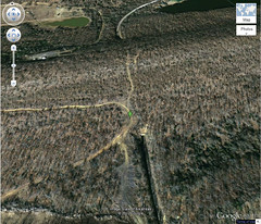
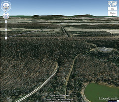
I tried to get the same results with the Google Earth app, but couldn't manage it. The Google Earth plugin at Google Maps just had a nicer 3D view.
If you're ever in La Flore County near the Oklahoma / Arkansas border north of Poteau, you might want to check out the Jenson Tunnel. It is an active railway. I do not advise you enter the tunnel. Just look at the entryways. Please keep your eyes and ears open, and never take any chances when it comes to your safety, especially around trains.